This morning, Lori and I are attempting one of the most popular, longest, and most misunderstood hikes around Sayulita.
We’ll be walking on foot from the town of Sayulita (where we’re currently based), to the next town north, San Francisco – better known as San Pancho.
Only three miles separate these two towns. But, as we mentioned in a recent post, that’s three miles of dense and mountainous jungle (as you’ll soon see), with exactly one road connecting the Sayulita and San Pancho. That road is Federal Route 200, the main north-south highway here. Golf carts are strictly prohibited, and walking along the highway is highly discouraged.
But you can hike between the two in a matter of hours.
Why is the hike so misunderstood, you ask?
There is a widely held belief by most visitors to the area that you can get from Sayulita to San Pancho (and vice versa) by walking along the beach.
And you should be able to. In fact, not so long ago, you could walk with ease from North Sayulita to Playa San Pancho via Playa Malpaso (the beach we frequently hike to that features prominently in our Sayulita posts).
It should be a simple matter of covering the two-miles of pristine Malpaso beach on foot, then cutting through the jungle 50 yards or so and popping out on San Pancho beach.
Unfortunately, a luxury beach resort dominates the small rocky point separating the two beaches. And the owners have gone to great lengths to make sure NO ONE who isn’t a paying guest passes anywhere near the property.
The alternative? A 6+ mile sojourn up and over mountains, through dense jungle, and along a narrow, busy highway.

Which is what we’re about to attempt today.

As we previously mentioned, many visitors to San Pancho believe it is the location of a powerful Vortex. Apparently, it’s also what’s on the other side of rainbow. That’s where we’re headed. We’ll see if we find the pot of gold.

For its popularity, there isn’t a lot you’ll find online about the ins and outs of this hike. I’ve downloaded a couple of old tracks from AllTrails, but also discovered a number of other tracks for lesser known paths.
Most hikers follow the route to Malpaso for the first few miles of the hike, before starting their climb into the mountains. Since we do that hike a lot, we’re eager to discover something new. I’ve got a few different options that may or may not exist logged into my phone’s Map app (Gaia GPS is what I use).
We’ll see how they pan out.

After crossing the main road connecting Highway 200 with Malpaso Beach, we take a right and find a narrow path leading through the jungle, just east of the main road we usually trace.
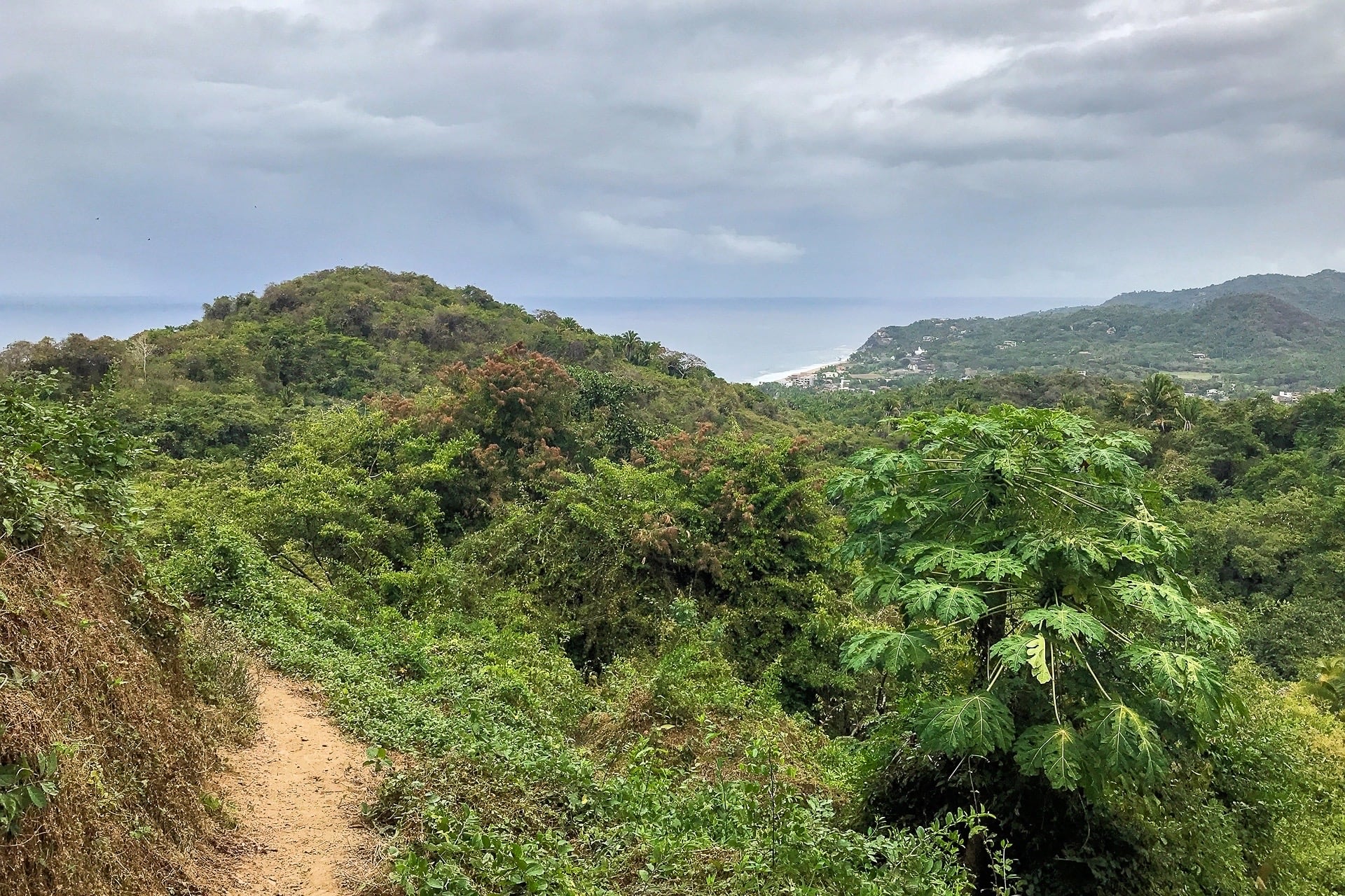
We discover that this path continues on for miles, climbing up into the densely forested hills, headed in the general direction of San Pancho. This well maintained path is not plotted on the public map. But we do encounter a handful of trail runners along the way.
At one point, the path is abruptly bisected by what appears to be a brand new road in the works. Curious, we follow the road downhill towards the Pacific for some time until we decide enough is enough and turn back around.

Sadly, it appears to be the beginnings of some sort of housing development, right smack in the middle of pristine jungle. No telling where Sayulita is headed with all this, but we can see the writing on the wall, unfortunately.
Back on the trail, we find ourselves climbing ever higher, until we suddenly emerge from dense jungle and our first view of San Pancho appears.

From here, I have a good idea of how we’re going to join up with the main trail that will take us most of the rest of the way into town. But I also have a GPS trace from hiker who attempted to find another route straight down to San Pancho beach from here.

The possibility of being able to skip the dreaded highway segment and head straight to the beach is very enticing, so we skirt the main trail and attempt to find the alternative hidden route.

After a couple of dead ends at viewpoints, we get back on the main trail, which eventually connects to a cobblestone road. Taking a right here is more or less guaranteed to lead to the highway, and then central San Pancho. There is no indication of a road leading to the left on my map, in the direction of San Pancho beach… Weird.
We take the left.
We follow the cobblestone road uphill until we are just about to intersect a possible path down to the beach that I have plotted on my GPS app. Right then, a security guard on a motorbike rides out of the bushes and informs us we are on private property and are not permitted to continue. We ask him if there is another path from here down to the beach and he says there is not. And that’s that.
In retrospect, looking at our hike trace on my phone that evening, it’s clear that that is the road to the greedy, hoity, toity resort perched on the point (the resort is called Villa Vista Magica, by the way, and they’ve gained quite a legion of haters on social media for their blockade, which is in all likelihood against the law following a new public beach access law going into effect last October. But still, they persist.
Fortunately, they have not closed off access to the inland hiking trail from Sayulita (as they technically own the last hundred meters or so).

The last ten minutes of the hike were our least favorite. Because of another greedy luxury resort blocking access to the first road into town, hikers are forced to walk along the very narrow (or non-existent) shoulder of the region’s major north-south highway for the last ten minutes into town. Due to the number of large construction vehicles and 18-wheelers on the road, we decided to pick up the pace and jog the last quarter mile or so into San Pancho.

We made it! Welcome to San Pancho!
Time to grab some lunch and a taxi back to Sayulita!


